The authority, the schemes and the zoning
Dholera SIR, explained.
Special Investment Region is a legal status, not a marketing word. It creates an authority, a plan and a set of regulations that decide what you can do with a plot. Here is how that machinery works.
The machinery
Who decides what happens here.
Three names come up on every document in Dholera. It is worth knowing which does what.
The SIR Act, 2009
Gujarat passed the Special Investment Region Act in January 2009 and notified Dholera SIR in May 2009. The Act is what allows a region to be planned and governed separately from the normal municipal structure.
2009DSIRDA
The Dholera Special Investment Region Development Authority, formed in February 2010. It is the planning and regulatory body, and it sanctions the town planning schemes.
AuthorityDICDL
Dholera Industrial City Development Limited, formed in January 2016 as the special purpose vehicle that actually builds and operates the trunk infrastructure. Gujarat holds 51% and the Government of India 49%.
DeveloperThe DCR
The Development Control Regulations, sanctioned in September 2012 alongside the development plan. These set land use, building norms and what you are permitted to construct on a given plot.
RulesIf a seller cannot tell you which town planning scheme a plot sits in, they cannot tell you what you are allowed to build on it either.
The schemes
Six schemes, 422.42 sq km.
The developable part of the region is divided into six town planning schemes, and then into 27 sub schemes for phased development. Every plot sits in exactly one of them.
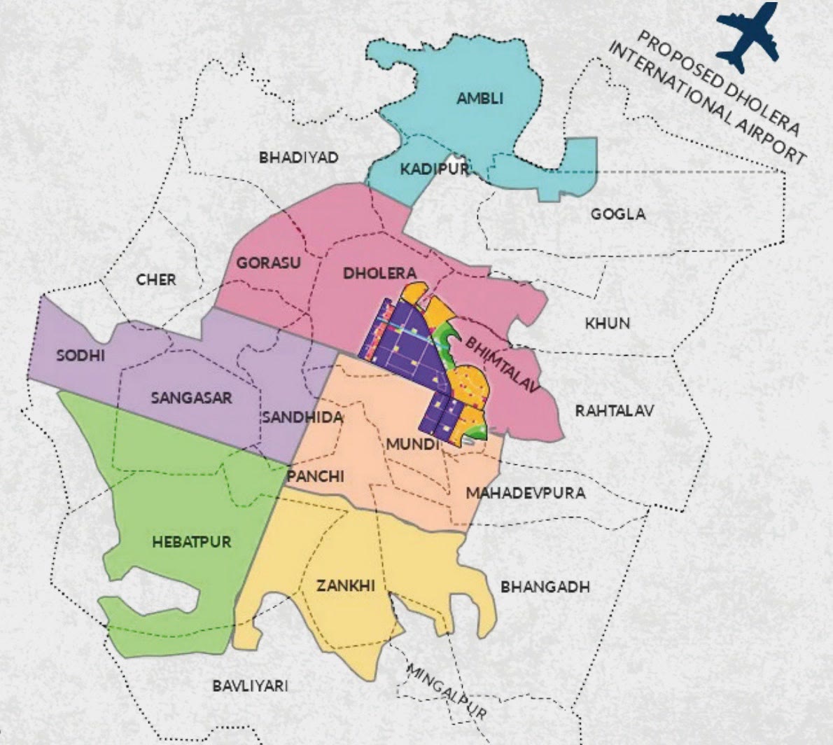

What the colours mean
Every plot in Dholera carries a land use from this plan. It decides what can be built on it, and it is the single fact that most changes what a plot is worth. It is also the one people check last.
- Industrial
- Knowledge and IT
- Public facilities
- Residential
- High access corridor
- Logistics
- City centre
- Agriculture
- Tourism and resort
- Green space
- Coastal regulation zone
- Recreation, sports and entertainment
Around 60% of the region is planned as green and open space and 40% as urban development. Ask for the land use of the exact survey number you are shown, not the zone of the area around it.
The first phase
The Activation Area.
22.5 sq km, about 5,600 acres, at the centre of the region across TP2 and TP4. It is the part of Dholera that is built rather than drawn.
22.5sq km
The area of the first phase, roughly 5,600 acres.
Phase 1
2017
L&T began physical work on roads and underground utilities.
On site
2019
The ABCD command and control centre became operational.
Running
2022
Trunk infrastructure operational and land allotment opened to industry.
Complete
180.5sq km
The area of upcoming development across TP1 to TP6 beyond the first phase.
Next
27sub schemes
The six schemes are divided into 27 sub schemes for phased delivery.
Phasing
Inside the Activation Area, infrastructure exists now. Outside it, you are buying the plan and the timeline that comes with it. Both can be reasonable. They are not the same purchase.
Common questions
What people ask about the SIR.
It is a legal status created by the Gujarat SIR Act of 2009. It lets a region be planned and governed by its own authority, with its own development plan and its own development control regulations, separately from the normal municipal structure.
Different, not better. Inside, the sanctioned land use and the DCR apply, and trunk infrastructure is planned to reach it. Outside, those regulations do not apply, which usually means faster approvals and fewer restrictions, but the master plan is not your document.
A town planning scheme fixes the road network and the land use for every plot inside it. Your plot sits in exactly one of the six, and that scheme document is what governs it. Ask which one, by number.
The 22.5 sq km first phase across TP2 and TP4, about 5,600 acres. Roads, power, water, drainage and fibre are in the ground, and the command centre has run since 2019.
The survey number and title chain with an independent lawyer, and the land use and scheme with the sanctioned town planning scheme document. Not with the seller, including us.
Talk to us
Ready to explore Dholera?
Tell us what you are looking for and we will send options that actually fit. No spam, no pressure, no daily calls.